
第 1/3 張圖片


已結束
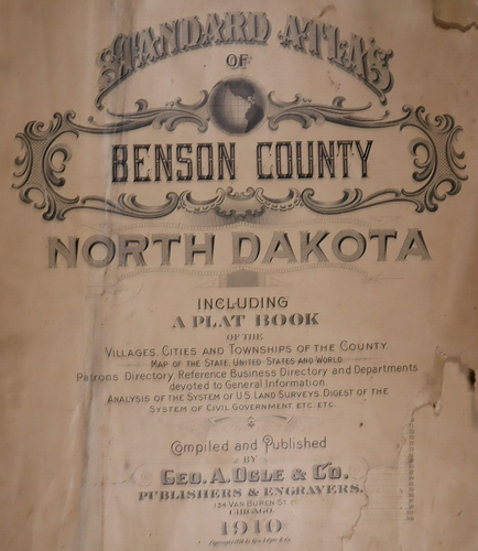
1910 Atlas Map ~ THE WORLD w/ OCEAN ROUTES ~ Free S&H - Large (17" x 29")
狀況:
“Quick N Free S&H ~ Reasonable offers considered. Browse through 1,000s of Rare, Authentic, Antique & ”... 閱讀更多內容關於物品狀況
結束時間: 2024-05-16 03:42:00
運費:
所在地:Schertz, Texas, 美國
送達日期:
估計於 7月1日, 一至 7月5日, 五之間送達 運送地點 43230
退貨:
保障:
請參閱物品說明或聯絡賣家以取得詳細資料。閱覽全部詳情查看保障詳情
(不符合「eBay 買家保障方案」資格)
賣家必須承擔此刊登物品的所有責任。
eBay 物品編號:404970807491
物品細節
- 賣家備註
- Date Range
- 1910
- Frame
- Suitable for framing.
- Type
- County Map
- Format
- Atlas Map
- Year
- 1910
- Ref#
- BENSON-ND1910/022523
- Color
- All colors are original.
- Cartographer/Publisher
- Geo. A. Ogle
- Original/Reproduction
- Antique Original
- Country/Region
- United States of America
- Original
- This map page was printed in 1910.
賣家提供的物品說明
賣家必須承擔此刊登物品的所有責任。
eBay 物品編號:404970807491
運費與處理費
物品所在地:
Schertz, Texas, 美國
運送地點
全球
排除:
俄羅斯聯邦, 利比亞, 委內瑞拉, 巴貝多, 新喀里多尼亞, 法屬圭亞那, 法屬玻里尼西亞, 烏克蘭, 瓜德羅普島, 留尼汪島, 馬提尼克島
| 運費與處理費 | 運送地點 | 運送方式 | 運送*查看送達備註 |
|---|---|---|---|
| 免運費 | 美國 | 標準運送方式 (USPS Ground Advantage®) | 估計於 7月1日, 一至 7月5日, 五之間送達 運送地點 43230 |
| 稅項 |
|---|
| 結賬時相關稅項可能適用。 進一步了解進一步了解為 eBay 購物繳稅。 |
物品編號 404970807491 的銷售稅
物品編號 404970807491 的銷售稅
賣家會對寄往以下各州的物品收取銷售稅:
| 州/省 | 銷售稅稅率 |
|---|
退貨政策
| 收到物品後聯絡賣家的期限: | 退款方式 |
|---|---|
| 30 日 | 退款 |
買家負責支付退貨運費。
