- 已結束 2024 年 6 月 25 日c.1885 Antique Map of Geology and Coal Fields in England and Wales by A&C BlackOpens in a new window or tab提供海關服務及全球追蹤資料shrubbster (282) 100%
- 已結束 2024 年 6 月 25 日Antique Map: Taunton, Somerset, & Exmoor by John Bartholomew, Survey Atlas, 1903Opens in a new window or tab提供海關服務及全球追蹤資料theclubhousevintage (1,653) 100%
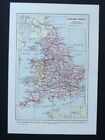
- 已賣出 2024 年 6 月 24 日1902 Map of Oxford Essex Sussex Surrey antique vintage Britannica 10thOpens in a new window or tabsilicon-press (193) 100%
- 已賣出 2024 年 6 月 24 日1891 Corsica & Sardinia Hand Coloured Original Antique Map by G.W. BaconOpens in a new window or tab高度評價賣家高度評價賣家diddersgoods (2,954) 100%
- 已結束 2024 年 6 月 24 日c.1885 Antique Map of Berks, Bucks and Oxford by A&C Black, London. Plate 12Opens in a new window or tab提供海關服務及全球追蹤資料shrubbster (282) 100%
- 已結束 2024 年 6 月 24 日c.1885 Antique Map of Southampton and Portsmouth by A&C Black, London. Plate 62Opens in a new window or tab提供海關服務及全球追蹤資料shrubbster (282) 100%
- 已結束 2024 年 6 月 24 日c.1885 Antique Map of Parliamentary Divisions in England and Wales by A&C BlackOpens in a new window or tab提供海關服務及全球追蹤資料shrubbster (282) 100%
- 已結束 2024 年 6 月 24 日c.1885 Antique Map of Parliamentary Boroughs in England by A&C Black, London.Opens in a new window or tab提供海關服務及全球追蹤資料shrubbster (282) 100%
- 已結束 2024 年 6 月 23 日1750 ANTIQUE COPPER PLATE MAP - SICILIA ANTIQUA SICILY ITALY - SEALE / CELLARIUSOpens in a new window or tab提供海關服務及全球追蹤資料roundbarrow (3,957) 100%
- 已結束 2024 年 6 月 22 日c.1885 Antique Map of Parliamentary Divisions in Cambridge and HuntingdonOpens in a new window or tab提供海關服務及全球追蹤資料shrubbster (282) 100%
- 已結束 2024 年 6 月 22 日1749 nice ORIGINAL MAP ITALY PIEDMONT COTE D'AZUR FRANCE TURIN NICE LIGURIAOpens in a new window or tab高度評價賣家高度評價賣家artlusatica (1,305) 98.6%
- 已結束 2024 年 6 月 22 日Antique Map: England & Wales (North), United Kingdom, Universal Atlas, 1893Opens in a new window or tab提供海關服務及全球追蹤資料theclubhousevintage (1,653) 100%
- 已結束 2024 年 6 月 22 日Vintage Map: England & Wales, New Universal Encyclopedia, 1949Opens in a new window or tab提供海關服務及全球追蹤資料theclubhousevintage (1,653) 100%
- 已結束 2024 年 6 月 22 日Antique Map: England & Wales Counties by John Bartholomew, Survey Atlas, 1903Opens in a new window or tab提供海關服務及全球追蹤資料theclubhousevintage (1,653) 100%
- 已結束 2024 年 6 月 21 日Antique EUROPE DIVIDED INTO ITS EMPIRES, KINGDOMS, & STATES' Kitchin MAPOpens in a new window or tabbplilly2004 (741) 100%
- 已結束 2024 年 6 月 21 日Antique 1795 'EUROPE DIVIDED INTO ITS EMPIRES, KINGDOMS, & STATES' Kitchin MAPOpens in a new window or tabbplilly2004 (741) 100%
- 已結束 2024 年 6 月 21 日Antique Map: Canterbury, Kent, by John Bartholomew, Survey Atlas, 1903, ColourOpens in a new window or tab提供海關服務及全球追蹤資料theclubhousevintage (1,653) 100%
- 已結束 2024 年 6 月 20 日1845 AUSTRIAN EMPIRE PRUSSIA Map ORIGINAL Central Europe Bohemia Holland ItalyOpens in a new window or tabselsa84 (5,154) 100%
- 已結束 2024 年 6 月 20 日1843 EUROPE Map ORIGINAL Prussia Austrian Empire German States Switzerland ItalyOpens in a new window or tabselsa84 (5,154) 100%
- 已結束 2024 年 6 月 20 日1839 British Isles Map ORIGINAL England Wales Scotland Ireland London DublinOpens in a new window or tabselsa84 (5,154) 100%
- 已結束 2024 年 6 月 20 日1816 ORIGINAL MAP GREECE ITALY SICILY CROATIA TURKEY MACEDONIA AEGEAN ARCHIPELAGOpens in a new window or tab高度評價賣家高度評價賣家artlusatica (1,305) 98.6%
- 已結束 2024 年 6 月 20 日1848 ORIGINAL MAP CROATIA SLOVENIA CARNIOLA ITALY AUSTRIA ISTRIA TRIEST LAIBACHOpens in a new window or tab高度評價賣家高度評價賣家artlusatica (1,305) 98.6%
- 已結束 2024 年 6 月 20 日Antique Map: Stieler's 1873 South-East Germany & North Italy by Hermann BerghausOpens in a new window or tab提供海關服務及全球追蹤資料theclubhousevintage (1,653) 100%
- 已結束 2024 年 6 月 20 日Antique Map: England & Wales (South), United Kingdom, Universal Atlas, 1893Opens in a new window or tab提供海關服務及全球追蹤資料theclubhousevintage (1,653) 100%
- 已結束 2024 年 6 月 20 日Antique Map: Leeds & Environs by W & A K Johnston, New Popular Educator, 1899Opens in a new window or tab提供海關服務及全球追蹤資料theclubhousevintage (1,653) 100%
- 已結束 2024 年 6 月 19 日Antique 1795 'EUROPE DIVIDED INTO ITS EMPIRES, KINGDOMS, & STATES' Kitchin MAPOpens in a new window or tabbplilly2004 (741) 100%
- 已結束 2024 年 6 月 19 日c.1885 Antique Map of Berks, Bucks and Oxford by A&C Black, London. Plate 12Opens in a new window or tab提供海關服務及全球追蹤資料shrubbster (282) 100%
- 已結束 2024 年 6 月 19 日c.1885 Antique Map of Southampton and Portsmouth by A&C Black, London. Plate 62Opens in a new window or tab提供海關服務及全球追蹤資料shrubbster (282) 100%
- 已賣出 2024 年 6 月 19 日c.1885 Antique Map of Rainfall in England & Wales for January &July by A&C BlackOpens in a new window or tab提供海關服務及全球追蹤資料shrubbster (282) 100%
- 已結束 2024 年 6 月 19 日c.1885 Antique Map of Parliamentary Divisions in England and Wales by A&C BlackOpens in a new window or tab提供海關服務及全球追蹤資料shrubbster (282) 100%
- 已結束 2024 年 6 月 19 日c.1885 Antique Map of Parliamentary Boroughs in England by A&C Black, London.Opens in a new window or tab提供海關服務及全球追蹤資料shrubbster (282) 100%
- 已結束 2024 年 6 月 19 日Antique Map: Thames Estuary, Kent, Essex by John Bartholomew, Survey Atlas, 1903Opens in a new window or tab提供海關服務及全球追蹤資料theclubhousevintage (1,653) 100%
- 已結束 2024 年 6 月 19 日Antique Map: London & Gravesend, Kent, by John Bartholomew, Survey Atlas, 1903Opens in a new window or tab提供海關服務及全球追蹤資料theclubhousevintage (1,653) 100%
- 已賣出 2024 年 6 月 18 日1871 British Isles Large Original Antique Hand Coloured Map by Heinrich KiepertOpens in a new window or tab高度評價賣家高度評價賣家diddersgoods (2,954) 100%
- 已賣出 2024 年 6 月 18 日1843 EUROPE Map ORIGINAL England Spain Austrian Empire Prussia Italy GermanyOpens in a new window or tabselsa84 (5,154) 100%
- 已結束 2024 年 6 月 18 日Antique Map: Taunton, Somerset, & Exmoor by John Bartholomew, Survey Atlas, 1903Opens in a new window or tab提供海關服務及全球追蹤資料theclubhousevintage (1,653) 100%
- 已結束 2024 年 6 月 17 日c.1885 Antique Map of Parliamentary Divisions in Cambridge and HuntingdonOpens in a new window or tab提供海關服務及全球追蹤資料shrubbster (282) 100%
- 已賣出 2024 年 6 月 16 日c1895 Map of Etna, Sicily Italy antique vintage Britannica 9thOpens in a new window or tabsilicon-press (193) 100%
- 已結束 2024 年 6 月 16 日1750 ANTIQUE COPPER PLATE MAP - SICILIA ANTIQUA SICILY ITALY - SEALE / CELLARIUSOpens in a new window or tab提供海關服務及全球追蹤資料roundbarrow (3,957) 100%
- 已結束 2024 年 6 月 16 日1750 ORIGINAL MAP ITALY SICILY TUSCANY PIEDMONT LOMBARDY CALABRIA NAPLES CROATIAOpens in a new window or tab高度評價賣家高度評價賣家artlusatica (1,305) 98.6%
- 已結束 2024 年 6 月 16 日1816 ORIGINAL MAP ITALY MALTA SICILY SARDINIA PALERMO NAPLES CAGLIARI BARI ROMEOpens in a new window or tab高度評價賣家高度評價賣家artlusatica (1,305) 98.6%
- 已結束 2024 年 6 月 16 日1816 ORIGINAL MAP ITALY CROATIA BOSNIA SLOVENIA LOMBARDY VENICE TUSCANY ROMEOpens in a new window or tab高度評價賣家高度評價賣家artlusatica (1,305) 98.6%
- 已賣出 2024 年 6 月 15 日Framed NORFOLK, James Pigot Original Antique County Map c1830Opens in a new window or tab提供海關服務及全球追蹤資料dastr-23 (3,081) 99.6%
- 已結束 2024 年 6 月 15 日Antique Map: England & Wales (North), United Kingdom, Universal Atlas, 1893Opens in a new window or tab提供海關服務及全球追蹤資料theclubhousevintage (1,653) 100%
- 已結束 2024 年 6 月 15 日Vintage Map: England & Wales, New Universal Encyclopedia, 1949Opens in a new window or tab提供海關服務及全球追蹤資料theclubhousevintage (1,653) 100%
- 已結束 2024 年 6 月 15 日Antique Map: England & Wales Counties by John Bartholomew, Survey Atlas, 1903Opens in a new window or tab提供海關服務及全球追蹤資料theclubhousevintage (1,653) 100%
- 已結束 2024 年 6 月 14 日c.1885 Antique Map of Berks, Bucks and Oxford by A&C Black, London. Plate 12Opens in a new window or tab提供海關服務及全球追蹤資料shrubbster (282) 100%
- 已結束 2024 年 6 月 14 日c.1885 Antique Map of Southampton and Portsmouth by A&C Black, London. Plate 62Opens in a new window or tab提供海關服務及全球追蹤資料shrubbster (282) 100%
- 已結束 2024 年 6 月 14 日c.1885 Antique Map of Rainfall in England & Wales for January &July by A&C BlackOpens in a new window or tab提供海關服務及全球追蹤資料shrubbster (282) 100%
- 已結束 2024 年 6 月 14 日c.1885 Antique Map of Parliamentary Divisions in England and Wales by A&C BlackOpens in a new window or tab提供海關服務及全球追蹤資料shrubbster (282) 100%
- 已結束 2024 年 6 月 14 日c.1885 Antique Map of Parliamentary Boroughs in England by A&C Black, London.Opens in a new window or tab提供海關服務及全球追蹤資料shrubbster (282) 100%
- 已結束 2024 年 6 月 14 日Antique Map: Canterbury, Kent, by John Bartholomew, Survey Atlas, 1903, ColourOpens in a new window or tab提供海關服務及全球追蹤資料theclubhousevintage (1,653) 100%
- 已結束 2024 年 6 月 13 日Antique Map: Stieler's 1873 South-East Germany & North Italy by Hermann BerghausOpens in a new window or tab提供海關服務及全球追蹤資料theclubhousevintage (1,653) 100%
- 已結束 2024 年 6 月 13 日Antique Map: England & Wales (South), United Kingdom, Universal Atlas, 1893Opens in a new window or tab提供海關服務及全球追蹤資料theclubhousevintage (1,653) 100%
- 已結束 2024 年 6 月 13 日Antique Map: Leeds & Environs by W & A K Johnston, New Popular Educator, 1899Opens in a new window or tab提供海關服務及全球追蹤資料theclubhousevintage (1,653) 100%
- 已結束 2024 年 6 月 12 日c.1885 Antique Map of Parliamentary Divisions in Cambridge and HuntingdonOpens in a new window or tab提供海關服務及全球追蹤資料shrubbster (282) 100%
- 已結束 2024 年 6 月 12 日Antique Map: Thames Estuary, Kent, Essex by John Bartholomew, Survey Atlas, 1903Opens in a new window or tab提供海關服務及全球追蹤資料theclubhousevintage (1,653) 100%
- 已結束 2024 年 6 月 12 日Antique Map: London & Gravesend, Kent, by John Bartholomew, Survey Atlas, 1903Opens in a new window or tab提供海關服務及全球追蹤資料theclubhousevintage (1,653) 100%
- 已賣出 2024 年 6 月 11 日1853 British Isles Map ORIGINAL England Wales Scotland Ireland London DublinOpens in a new window or tabselsa84 (5,154) 100%
- 每頁顯示物品數目
 | 按類別選購 |
{"delay":300}